Events
محاضرة ومعرض
Lecture
Abdelbaseer Mohamed
04 May
2016 - 19 : 00
محاضرة
عبدالبصير محمد
The Disadvantaged Groups in Cairo: Sleepwalking into segregation?
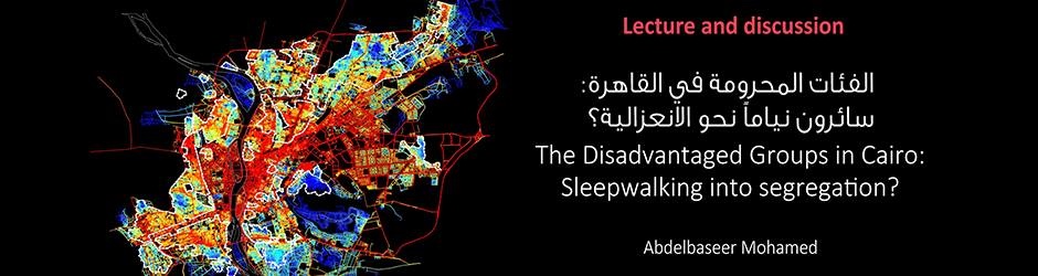
Spatial segregation intensifies social segregation. The current planning practice contributes to a spatial structure on the street and road network generating social and physical segregation between neighborhoods. The spatial relationship between local centers and the overall metropolitan network fragments in comparison to the past. This contribution shows the implications of the spatial configuration of the street network on the socio-economic profile in neighborhoods in Cairo.
The urbanization process in Cairo is analysed in various periods from 1517 to 2012 using space syntax techniques to understand urban transformation processes and the emergence of urban centers and segregated areas. In a second step, available data from 2006 on poverty, literacy and unemployment are correlated with space syntax analysis from 2012.
As it turns out, social factors are significantly correlated with the spatial structure of the street grid on a metropolitan scale level. On a local scale, disadvantaged areas have a high locally integrated spatial structure, but lack accessibility to the surrounding areas and the whole city. Seemingly, the connection between a main route network and various neighborhoods might influence a neighborhood’s social as well as economic integration. The current planning practice in Cairo, however, contributes to change this spatial structure through separating vibrant urban centers from the main route network. The effect is that this planning practice intensifies the social segregation processes between various social groups.
Lecturer: Abdelbaseer A. Mohamed is an Assistant professor teaching several courses, including architectural design, townscape and urban design at Al-Azhar University, Faculty of Engineering, Department of Urban Planning. He recently completed his PhD at Ain Shams University and Cologne University of Applied Sciences. As an architect and urban planner he also designed various types of buildings and participated in different public and private sector projects on regional and urban planning.
الفئات المحرومة في القاهرة: سائرون نياماً نحو الانعزالية؟
يكثف الفصل العمراني من العزل الاجتماعي في نفس الوقت تساهم الممارسات العمرانية الحالية في تشكيل شبكة الطرق بالمدينة وفي الفصل العمراني والاجتماعي. وقد أظهر التحليل الفراغي للقاهرة في الفترة مابين 1517 و 2012 أن المراكز الحضرية الحالية تبدو منفصلة عن بعضها وغير مترابطة فراغياً مقارنة بالماضي. وتعكس نتائج الدراسة دور العوامل الفراغية في تشكيل الظروف الاجتماعية والأقتصادية لسكان القاهرة وتلقي مزيداً من الضوء على حياة الفئات المهمشة.
وقد أظهرت النتائج أن علاقة المنطقة بمناطق الجوار يعكس كفاءة ادائها الوظيفي وشبكة العلاقات الاجتماعية والطابع والنواحي الثقافيه التي تعطيها هويتها وتميزها عن غيرها. ومن ناحية أخرى تعكس علاقة منطقة عمرانية ما بالنطاق الاشمل على مستوى المدينة مدى تكامل تلك المنطقة عمرانياً واندماجها اجتماعياً واقتصادياً في المجتمع المضيف.
وقد تبين من خلال الدراسة ان المناطق المحرومة والعشوائية تعمل بشكل جيد على مستوى مناطق الجوار أو النطاق المحلي ويتجلى ذلك في ظهور أنشطة أقتصادية غير رسمية تحقق دخلا وتلبي أحتياجات سكان تلك المناطق وفي حفاظ سكان هذه المناطق على عاداتهم وتقاليدهم والتي تعكس اصولهم الريفية كما يظهر أيضاً ترابط اجتماعي قوي في الكثير من تلك المناطق. غير أن تلك المناطق لا تعمل بشكل جيد على مستوى المدينة ككل فتظهر منعزلة عما حولها اجتماعيا وأقتصادياً وعمرانياً وتبدو وكأنها جزر مستقلة.
المحاضر: عبدالبصير محمد
معماري ومخطط عمراني حاصل على الدكتوراة في التصميم العمراني من جماعة عين شمس وجامعة كولونيا للعلوم التطبيقية. عمل كباحث زائر بالجامعة الأمريكية بواشنطن ويعمل حالياً مدرس بقسم التخطيط العمراني بهندسة الأزهر بالقاهرة.